Welcome to Lassen Volcanic National Park
Welcome to the Lassen Volcanic National Park Information Page
Here you will find all you need to know about the natural history of the park.
Learn about the geology, trees, mammals, birds, or other plants and wildlife of the area.
Lassen Volcanic National Park is located about eight miles northeast of Mineral, CA, or fifty miles east of Red Bluff, CA on Highway 36 or 50 miles east of Redding, CA on Highway 44.
How to get to Lassen Volcanic National Park
The closest major airport to Lassen Volcanic National Park is Reno, NV with smaller airports at Redding and Chico, CA.
From the North
1. Take I-5 South to Redding, CA to Stateroad 44 East to the park.
2. Take I-5 South to Stateroad 89 South to Stateroad 44 / 89 South to the park.
From the East
1. Take I-80 West to Highway 395 North to Stateroad 36 West to the park.
From the South
1. Take I-5 North to Red Bluff, CA then take Stateroad 36 East to the park.
From the West
1. Take Stateroad 299 East to Redding, CA to Stateroad 44 East to the park.
2. Take Stateroad 36 East to Red Bluff, CA then take Stateroad 36 East to the park.
Transportation
The best access to the park is by private automobile. Auto rental services are available in Redding, Red Bluff, Chico, Susanville or Reno. Greyhound and Trailways bus lines serve cities within 60 miles of the park. Major airlines serve Redding, Chico and Reno.
Establishment of Lassen Volcanic National Park
Lassen Volcanic National Park was officially established on August 9, 1916, becoming one of the early additions to the United States’ National Park System. The park was created to protect and preserve the area’s unique volcanic features, active geothermal sites, and rugged mountain landscapes formed by centuries of volcanic activity.
Historical Background
Long before it became a national park, the Lassen area was home to Indigenous peoples — including the Yana, Atsugewi, and Maidu tribes — who lived, hunted, and gathered in the region for thousands of years. They respected Lassen Peak as a sacred and powerful mountain.
In the mid-1800s, European settlers arrived. Peter Lassen, a Danish-American frontiersman and explorer, led settlers through Northern California; the peak and later the park were named after him.
The 1914–1915 Eruptions
Lassen Peak began showing signs of activity in May 1914, marking the start of a series of eruptions that lasted nearly two years. The most significant explosion occurred on May 22, 1915, sending a massive column of ash 30,000 feet into the air and generating a pyroclastic flow that destroyed nearby forests. This event dramatically reshaped the surrounding landscape and captured nationwide attention.
These eruptions made Lassen Peak the only volcano in the continental U.S. to erupt in the 20th century before Mount St. Helens in 1980. Scientists and geologists were drawn to the area to study the effects of volcanic activity.
Path to National Park Status
Recognizing the scientific importance and natural beauty of the region, President Theodore Roosevelt first took steps toward protection in 1907, designating Cinder Cone National Monument and Lassen Peak National Monument.
A few years later, after the 1915 eruptions, there was growing public interest in preserving the area as a national park. This led to Congress combining the two monuments into one larger protected area.
On August 9, 1916, President Woodrow Wilson signed the act establishing Lassen Volcanic National Park, protecting over 106,000 acres of volcanic peaks, steaming fumaroles, boiling mud pots, and pristine mountain lakes.
Significance Today
Today, Lassen Volcanic National Park stands as a living laboratory where visitors can witness the power of Earth’s geothermal energy and the resilience of nature. The park preserves:
- All four types of volcanoes (shield, plug dome, composite, and cinder cone)
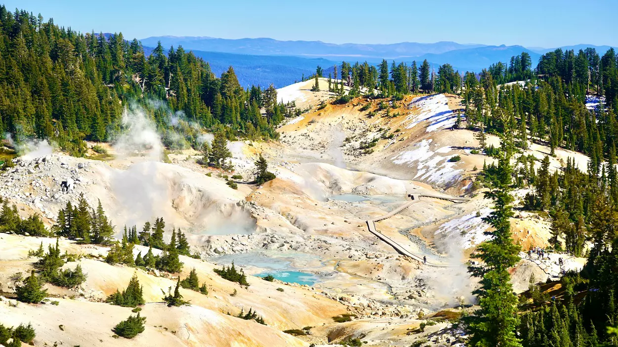
- Active geothermal areas like Bumpass Hell and Sulphur Works
- Lush alpine meadows, crystal-clear lakes, and subalpine forests
It continues to inspire scientists, adventurers, and travelers who come to explore its diverse and dynamic landscape.
Key Dates at a Glance
| Year | Event |
|---|---|
| 1907 | Lassen Peak & Cinder Cone declared National Monuments by President Theodore Roosevelt |
| 1914–1915 | Series of Lassen Peak eruptions occur |
| 1916 | Lassen Volcanic National Park established by President Woodrow Wilson |
| 1980 | Mount St. Helens eruption renews scientific interest in Lassen |
| 2016 | Park celebrates its 100th anniversary |
Size and Visitation of Lassen Volcanic National Park
Size of Lassen Volcanic National Park
Lassen Volcanic National Park covers approximately 106,452 acres (about 430 square kilometers) in northeastern California, within the southernmost section of the Cascade Mountain Range.
The park’s landscape is incredibly diverse — ranging from steaming hydrothermal basins and volcanic peaks to alpine meadows and serene mountain lakes. It includes all four major types of volcanoes — shield, plug dome, cinder cone, and composite — making it one of the most geologically fascinating places in North America.
Elevations within the park vary from around 5,000 feet (1,524 meters) at Manzanita Lake to over 10,457 feet (3,187 meters) at the summit of Lassen Peak, offering a wide range of ecosystems and climates in a relatively compact area.
Visitation Statistics
While Lassen Volcanic National Park is one of California’s most scenic national parks, it remains less crowded than popular destinations like Yosemite or Sequoia.
According to the National Park Service (NPS), the park typically welcomes around 400,000 to 500,000 visitors each year, depending on weather conditions, wildfire impacts, and road accessibility.
Visitation patterns vary significantly by season:
- Summer (July–September): Peak season, when all park roads and trails are open and accessible.
- Spring (May–June): Moderate visitation, with snow still melting at higher elevations.
- Fall (October): Fewer crowds, cooler temperatures, and colorful foliage.
- Winter (November–April): Light visitation; popular with snowshoers and cross-country skiers.
Despite its smaller crowds, Lassen offers world-class scenery and serenity, making it ideal for travelers seeking quiet exploration and uncrowded hiking trails.
Why Lassen’s Visitor Numbers Are Lower
Several factors contribute to Lassen’s relatively modest visitation:
- Remote location — It’s several hours from major urban centers.
- Short summer season — Snow often lingers well into June, limiting access.
- Wildfire and road closures in recent years have affected annual visitation totals.
However, these same factors help preserve the park’s tranquil atmosphere, making it a favorite for nature enthusiasts who value solitude and pristine wilderness.
Volcanic History
In May 1914, Lassen Peak burst into eruption, beginning a 7-year cycle of sporadic volcanic outbursts. The climax of this episode took place in 1915, when the peak blew an enormous mushroom cloud some 7 miles into the stratosphere. The reawakening of this volcano, which began as a vent on a large extinct volcano known as Tehama, profoundly altered the surrounding landscape. The park is a compact laboratory of volcanic phenomena and associated thermal features except true geysers. It is part of a vast geographic unit – a great lava plateau with isolated volcanic peaks – that also encompasses Lava Beds National Monument, California, and Crater Lake National Park, Oregon.
Plant Life at Lassen Volcanic National Park
A Park of Diverse Ecosystems
Lassen Volcanic National Park is home to an incredibly diverse range of plant life, thanks to its wide range of elevations (from about 5,000 to over 10,000 feet), volcanic soils, and varying moisture levels. The park encompasses ecosystems that range from lush conifer forests to alpine meadows, each hosting unique plant communities adapted to the challenging mountain environment.
Vegetation Zones of Lassen
The park’s plant life can be divided into four main vegetation zones, based largely on elevation and climate.
1. Lower Montane Forest Zone (Below 6,500 ft)
This zone covers the lower slopes and valleys around areas like Manzanita Lake and the Warner Valley.
- Dominant Trees: Ponderosa pine, Jeffrey pine, incense cedar, Douglas-fir, and black oak.
- Understory Plants: Ceanothus, manzanita, snowberry, lupine, and currant bushes.
- Fun Fact: In the fall, black oaks turn golden-yellow, adding vibrant color to Lassen’s forests.
2. Upper Montane Forest Zone (6,500–8,000 ft)
As you climb higher, the forest becomes denser and cooler. Snow covers this region for much of the year, creating short but lush growing seasons.
- Dominant Trees: Red fir, white fir, mountain hemlock, and lodgepole pine.
- Wildflowers: Indian paintbrush, mule’s ears, lupine, and corn lily.
- Notable Areas: Summit Lake and the road to Bumpass Hell often showcase fields of summer wildflowers.
3. Subalpine Zone (8,000–9,500 ft)
Near Lassen Peak and other high elevations, trees become shorter and more widely spaced due to thin soils, cold temperatures, and strong winds.
- Dominant Trees: Whitebark pine, mountain hemlock, and western white pine.
- Plants: Alpine buckwheat, lupine, phlox, and penstemon thrive in meadows and rocky slopes.
- Fun Fact: Whitebark pines here are centuries old and play a crucial role in stabilizing fragile mountain soils.
4. Alpine Zone (Above 9,500 ft)
This is the harshest environment in Lassen — found mainly around the summit of Lassen Peak.
- Vegetation: Sparse and low-growing, including hardy mosses, lichens, sedges, and cushion plants.
- Adaptations: These plants survive in thin volcanic soils, freezing temperatures, and strong UV radiation.
Wildflowers of Lassen
Every summer, Lassen bursts into color as hundreds of wildflower species bloom across meadows, ridges, and lake shores.
Common wildflowers include:
- Scarlet Indian paintbrush
- Blue and purple lupines
- Yellow mule’s ears
- White mariposa lilies
- Pink shooting stars
- Corn lilies, often found in damp meadows
The best time to see wildflowers is typically mid-July through early August, depending on snowmelt.
Visitors Guide
Accessibility – Bumpass Hell Parking area portable restrooms are accessible with assistance. The Devastated Area Interpretive Trail and certain naturalist programs are accessible. The Loomis Museum restrooms, Camper Store Campground and Park Headquarters information desk and restrooms are accessible.
Basic Visit Recommendations – Allow at least three hours to drive across the park and to make stops. Allow at least two days to hike some of the spectacular trails.
Biking – Bicycles are permitted on park roads and in campgrounds but prohibited on all park trails. A helmet must be worn by cyclers under age 18. Skating, skateboarding, and rollerblading are not permitted.
Boating – Motorized boats are prohibited on all park waters. Coast Guard approved flotation devices must be on board for all occupants and worn by children under 12.
Lake Helen and Emerald, Reflection and Boiling Springs Lake are closed to boating. Boats may not be left on Manzanita or other lake shores overnight. At Manzanita Lake, boats may only be put in and taken out at the designated launch sites.
Camping – There are seven campgrounds in the park. Groups must camp in one of two group campgrounds (Lost Creek or Juniper Lake). Reservations for the group campgrounds are required and must be made in advance. Please contact 530-595-4444 ext. 5155 for information on group camping. All other park campgrounds operate on a first come, first served basis; no reservations can be made.
Fishing
Park fishing regulations conform with California State regulations.
A California State fishing license is required for those over 16.
Emerald Lake, Manzanita Creek and the part of Manzanita Lake within 150 ft of the inlet are closed to fishing.
Special regulations for Manzanita Lake:
Catch and release only; only artificial lures and single barbless hooks can be used.
Food and Supplies – The Lassen Chalet and Manzanita Lake Camper Store operate daily in the summer months and offer food and gifts. See the Lodging Page for local towns around the park.
Hiking – Lassen Volcanic National Park contains 150 miles of hiking trails, including 17 miles of Pacific Crest Trails. Trails vary in length and difficulty, winding through coniferous forest, alpine tundra and along water ways.
Pet Information at Lassen Volcanic National Park
Overview
Lassen Volcanic National Park welcomes pets — but with strict rules to protect wildlife, fragile habitats, and the safety of all visitors. If you’re planning to bring your furry companion, it’s important to know where pets are allowed (and not allowed) before you go.
While pets can enjoy many outdoor areas with you, they are not permitted on hiking trails, in backcountry areas, or inside park buildings. However, you can still explore plenty of scenic spots together along roads, campgrounds, and picnic areas.
Where Pets Are Allowed
Your pet is welcome in the following areas:
- 🛣 Along paved roads and parking lots
- 🏕 In campgrounds (on-leash only)
- 🧺 In picnic areas
- 🏞 In areas within 150 feet of roads and parking areas
These zones still offer great views and short walks where pets can safely enjoy the mountain air and volcanic scenery.
Where Pets Are Not Allowed
To protect wildlife and fragile volcanic terrain, pets are not permitted in:
- 🚫 Any hiking trails or boardwalks
- 🚫 Backcountry areas or wilderness zones
- 🚫 Lakeshores, including Manzanita Lake and Summit Lake
- 🚫 Inside visitor centers, cabins, or public buildings
- 🚫 Snow-covered routes, as snow may obscure trail boundaries
Even well-behaved pets can disturb wildlife or leave scent trails that disrupt natural behaviors, which is why these restrictions are carefully enforced.
Pet Rules and Requirements
All pets in Lassen must follow these regulations:
- 🦮 Always keep pets on a leash (maximum length: 6 feet).
- 💩 Clean up after your pet — pet waste bags are not provided, so bring your own.
- 🏕 Never leave pets unattended — especially in vehicles, as interior temperatures can rise quickly.
- 🌡 Protect your pet from heat and altitude — Lassen’s high elevations can affect animals more quickly than people.
- 🌲 Keep a respectful distance from wildlife — pets can easily provoke or be injured by wild animals.
Violation of these rules may result in fines.
Pet-Friendly Activities
Even with restrictions, you and your pet can still enjoy several fun experiences:
- Scenic drives along the Lassen Volcanic National Park Highway
- Leashed walks around campgrounds and picnic areas
- Relaxing by Manzanita Lake (in designated roadside areas only)
- Exploring nearby national forest lands, where pet rules are more flexible
Lassen’s neighboring Lassen National Forest and Caribou Wilderness areas offer many pet-friendly trails where you can hike together legally and safely.
Pet Safety Tips
Bring plenty of water, as volcanic terrain and high elevations can cause dehydration.
- Avoid hot hydrothermal areas — steam vents and boiling pools can be extremely dangerous for pets.
- Keep an eye on your pet’s paws — sharp lava rock and hot pavement can cause burns.
- If visiting in summer, plan early morning or evening outings to avoid high temperatures.
- Be mindful of bears and coyotes, which occasionally roam near campgrounds.
Weather of Lassen Volcanic National Park
Overview
The weather at Lassen Volcanic National Park is as dynamic and diverse as its volcanic landscape. Due to the park’s wide elevation range — from about 5,000 feet (1,524 m) at Manzanita Lake to 10,457 feet (3,187 m) at the summit of Lassen Peak — temperatures and conditions can vary dramatically within a few miles.
From snow-covered peaks to warm summer meadows, Lassen experiences all four seasons in full force, often on a grand scale. Visitors should be prepared for rapidly changing mountain weather at any time of year.
Four Distinct Seasons
🌨 Winter (November – April)
Winter in Lassen is long, cold, and snowy.
- Snowfall: The park receives an average of 30–40 feet (9–12 meters) of snow annually, especially at higher elevations.
- Temperatures: Daytime highs typically range from 20°F to 40°F (-6°C to 4°C), with nights dropping below freezing.
- Access: Most of the park highway (Highway 89) is closed due to snow, but areas near the southwest entrance and Kohm Yah-mah-nee Visitor Center remain open.
- Activities: Snowshoeing, cross-country skiing, and winter camping are popular.
Lassen’s deep winter snowpack can last well into late spring, shaping the park’s ecosystems and water flow.
🌸 Spring (May – June)
Spring arrives slowly at Lassen. Melting snow gives way to rushing creeks, waterfalls, and lush meadows filled with new growth.
- Temperatures: 40°F to 60°F (4°C to 16°C) during the day; nights remain chilly.
- Conditions: Snow often lingers above 7,000 feet through early June, and trails may still be covered or muddy.
- Highlights: Spring is ideal for photography and for seeing the park awaken after winter — though access may still be limited.
🌞 Summer (July – September)
Summer is the best and most popular time to visit Lassen Volcanic National Park.
- Temperatures: Average highs between 70°F and 80°F (21°C to 27°C) in lower areas; cooler near Lassen Peak.
- Weather: Clear skies, warm days, and cool nights are typical.
- Access: All park roads and trails are usually open, offering full access to volcanic features, lakes, and meadows.
- Highlights: Wildflowers bloom, trails are accessible, and ranger programs are in full swing.
Despite being summer, visitors should bring layers — temperatures can drop quickly after sunset.
🍂 Fall (October)
Autumn brings crisp air, golden foliage, and peaceful solitude.
- Temperatures: Highs average 50°F to 65°F (10°C to 18°C); nights can drop below freezing.
- Weather: Early snowstorms are possible by late October.
- Highlights: Smaller crowds, excellent photography conditions, and stunning views of fall colors — especially in the lower montane forests.
By late fall, snow begins to accumulate again, marking the transition back to winter.
Temperature and Precipitation Overview
| Season | Average High | Average Low | Precipitation |
|---|---|---|---|
| Winter (Nov–Apr) | 30°F – 40°F (-1°C – 4°C) | 10°F – 25°F (-12°C – -4°C) | Heavy snow |
| Spring (May–Jun) | 45°F – 65°F (7°C – 18°C) | 25°F – 40°F (-4°C – 4°C) | Moderate rain/snow |
| Summer (Jul–Sep) | 70°F – 80°F (21°C – 27°C) | 35°F – 50°F (2°C – 10°C) | Light rain |
| Fall (Oct) | 50°F – 65°F (10°C – 18°C) | 25°F – 35°F (-4°C – 2°C) | Light snow/rain |
20 FAQs About Lassen Volcanic National Park
1. Where is Lassen Volcanic National Park located?
Lassen Volcanic National Park is in northeastern California, within the Shasta Cascade region. It’s about 50 miles east of Redding and roughly a 4–5 hour drive from the San Francisco Bay Area.
2. What is Lassen Volcanic National Park known for?
The park is famous for its active volcanic landscape, including boiling mud pots, steaming fumaroles, and sulfur vents. It’s one of the few places in the world where all four types of volcanoes — plug dome, shield, cinder cone, and composite — can be found in one area.
3. When is the best time to visit Lassen Volcanic National Park?
The best time to visit is from July through September, when most roads and trails are snow-free. Spring brings waterfalls and wildflowers, while winter offers snowshoeing and skiing opportunities.
4. How big is Lassen Volcanic National Park?
The park covers about 106,000 acres of volcanic peaks, alpine lakes, meadows, and forests.
5. What are the top things to do in Lassen Volcanic National Park?
Popular activities include:
- Hiking Bumpass Hell and Lassen Peak
- Kayaking at Manzanita Lake
- Exploring the Sulphur Works
- Visiting Kings Creek Falls
- Stargazing under Lassen’s clear night skies
6. How do I get to Lassen Volcanic National Park?
You can access the park via Highway 44/89 from the north (Manzanita Lake Entrance) or Highway 36/89 from the south (Kohm Yah-mah-nee Visitor Center Entrance). The Lassen Volcanic National Park Highway (Highway 89) connects both entrances and crosses the park.
7. Is Lassen Peak still active?
Yes — Lassen Peak is considered an active volcano, though it hasn’t erupted since 1915. It’s closely monitored by the U.S. Geological Survey (USGS).
8. Can you hike to the top of Lassen Peak?
Yes! The Lassen Peak Trail is a 5-mile round-trip hike that climbs about 2,000 feet to the summit, offering panoramic views of Mount Shasta and surrounding landscapes.
9. What is Bumpass Hell?
Bumpass Hell is Lassen’s largest geothermal area. It features boiling pools, fumaroles, and mud pots accessible via a scenic 3-mile round-trip hike.
10. Are pets allowed in Lassen Volcanic National Park?
Pets are allowed in campgrounds, parking areas, and paved roads, but not on trails or in thermal areas. Always keep pets on a leash and never leave them unattended.
11. Do I need a reservation to enter Lassen Volcanic National Park?
No general reservation is required to enter. However, campgrounds and group sites may require reservations during peak summer months.
12. How much does it cost to visit Lassen Volcanic National Park?
As of 2025, the entrance fee is around $30 per vehicle for a 7-day pass. Annual passes and interagency passes (like the America the Beautiful Pass) are also accepted.
13. What kind of wildlife lives in Lassen Volcanic National Park?
Wildlife includes black bears, deer, coyotes, bobcats, marmots, eagles, and trout. Always observe animals from a safe distance and store food properly.
14. Is camping available in Lassen Volcanic National Park?
Yes — there are eight campgrounds, including Manzanita Lake, Summit Lake, and Butte Lake. Some are reservable, while others operate on a first-come, first-served basis.
15. Can you swim in the lakes at Lassen?
Swimming is allowed in most lakes, including Manzanita Lake and Summit Lake, though the water can be quite cold year-round.
16. What are the best easy hikes for beginners?
Some great beginner-friendly hikes include:
- Lily Pond Nature Trail (0.5 miles)
- Devastated Area Trail (0.5 miles)
- Manzanita Lake Loop (1.8 miles)
17. Is Lassen Volcanic National Park open year-round?
Yes, the park is open all year, but the main road (Highway 89) often closes from November to May due to heavy snowfall. The southwest area remains accessible in winter for snowshoeing and skiing.
18. What can you do in Lassen during winter?
Winter activities include snowshoeing, cross-country skiing, sledding, and winter camping near the Kohm Yah-mah-nee Visitor Center.
19. Are there guided tours or ranger programs available?
Yes — in summer, the park offers ranger-led hikes, campfire programs, and astronomy nights. Check the visitor center or NPS website for current schedules.
20. What should I bring when visiting Lassen Volcanic National Park?
Pack layered clothing, sturdy hiking shoes, sunscreen, water, a hat, insect repellent, and a map. Weather changes quickly at higher elevations, so be prepared for sudden temperature drops.
